Operator's Toolbox (OT) is an STK UI plugin designed to improve the efficiency of common operational tasks. This article contains detailed training for using OT. Attached to this article is a zipped folder containing a full tutorial PDF for each lesson and a starter tutorial scenario for Lesson 5. For further guidance, contact AGI support (support@agi.com).
Before starting the training, install the Operator's Toolbox and review the support material. See the
Operator's Toolbox Plugin FAQ for details on these.
As a preview, the following sections provide the problem statement and OT tools to use for each lesson.
Lesson 1: GPS Operations with Operator's Toolbox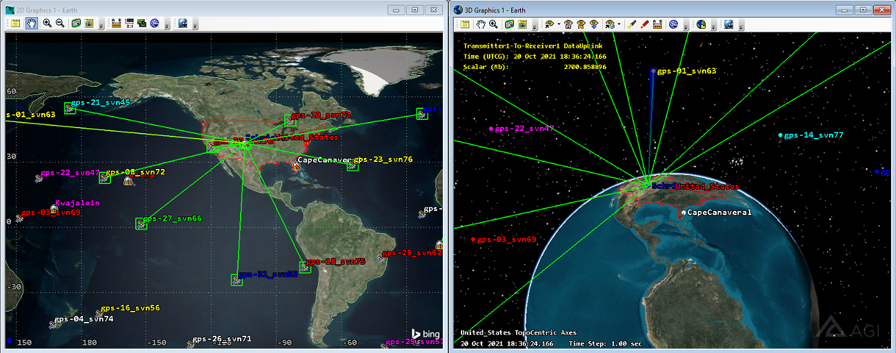 Problem Statement
:
The Global Positioning System (GPS) constellation serves many important functions, from military operations to civilian applications. The constellation enables GPS receivers to know when and where they are to a high degree of accuracy. As of early 2022, the GPS system is using 31 active satellites with orbit inclinations of 55 degrees from the equator. The satellites orbit about 20,000 km above Earth and make approximately two orbits per day. Although GPS uses complex technology, the application is rather simple. A GPS receiver gets a signal from each GPS satellite that is within view, telling the receiver information such as:
• Which satellites are actively transmitting to the receiver
• When the receiver received each signal
• Where the satellites are located at the signal time
From there, the receiver handles the computations to determine its own precise location on Earth. Leveraging GPS signals as a receiver is a rather simple process, but the operations that go into monitoring and maintaining the GPS constellation are far more complex. As of early 2022, there are six US Air Force monitoring stations, ten NGA monitoring stations, seven AFSCN remote tracking stations, and four ground antennas. All of these are distributed around the globe. This network has the responsibility of tracking and monitoring each GPS satellite as well as uplinking important data to the satellites, such as GPS ephemeris and clock data. Schriever Air Force Base in Colorado Springs, CO, serves as the master control station for relaying this information as well as maneuvering each GPS satellite. When communicating with GPS satellites, the Schriever transmitters use S-band receivers. In this tutorial, you will learn how to leverage OT to model and simulate the GPS constellation (including ground stations), compute continental United States GPS coverage, and determine times for Schriever AFB can communicate with each GPS satellite. This exercise is meant to demonstrate how you can streamline constellation operations by using STK's Operator's Toolbox plugin.
OT tools for Lesson 1: Templates, Coverage, Station Access
Lesson 2: Imaging Wildfires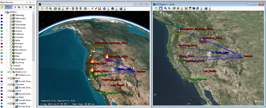 Problem statement
:
During the summer of 2021, the US experienced nearly 50,000 wildfires, with the most severe occurring in the western region. Due to the wildfires crossing state lines and being extreme in nature, firefighters from all over the nation provided aid in putting out these fires. One mechanism to combat the fires is the DC-10 Air Tanker, a jet airliner converted into an aerial firefighting unit. The aircraft can carry up to 12,000 gallons of water or fire retardant in the exterior tank mounted on the belly of the aircraft. In this lesson, you will model a firefighting mission using the DC-10 Air Tanker. The mission is to coordinate a firefighting response with the aid of Denver, CO, based DC-10 assets. In STK, you will model aircraft taking off from Denver to combat wildfires in Washington, Oregon, California, Idaho, and Nevada. Operators are concerned with the time duration of the aircraft arriving to and returning from the fires, and also with the larger mission view. You will also model a Low Earth Orbit (LEO) imaging constellation that is responsible for providing the most up-to-date imaging information on the wildfires. Finally, you will monitor the network of aircraft ground stations responsible for tracking the aircraft and providing the most up-to-date information on wildfire status.
OT tools for Lesson 2: Facility Creator, Templates, Coverage, Station Access, Volume Creator, Ground Events
Lesson 3: Planning a satellite launch with OT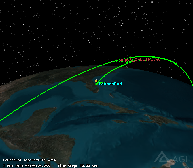 Problem statement
:
In this scenario, you will model an orbit injection launch from Cape Canaveral. You will use the Unified Data Library (UDL) Importer in Operator's Toolbox to download the International Space Station (ISS) ephemeris data. Next, you will import the ISS ephemeris into STK using Satellite Creator. Third, you will examine the times when the ISS crosses the plane of Cape Canaveral using the Plane Crossing Utility. The reason for doing this is that you want to launch the satellite such that it will inject into the same orbital plane as the ISS. Once you determine a time when the planes intersect, you will use STK's
Astrogator capability to optimize the launch epoch, target azimuth, target altitude, and target velocity.
OT tools for Lesson 3: Unified Data Library TLE Import, Satellite Creator, Plane Crossing Utility
Lesson 4: Satellite Imaging During a Rendezvous and Proximity Operations Mission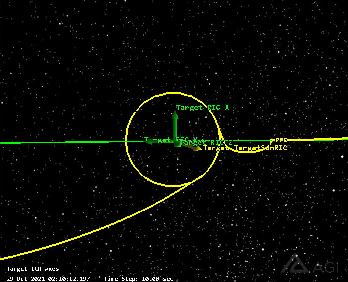
 Problem Statement
:
Rendezvous and Proximity Operation (RPO) mission planning can be a very complex and time-consuming process. Operators typically need strong astrodynamics skills, an understanding of numerical issues, and experience in scripting or programming. However, STK's
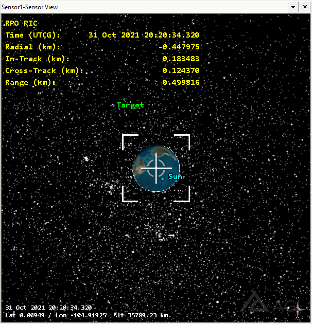
Astrogator capability has built-in RPO sequences to simplify the process for the everyday STK user. This tutorial covers the process of building an RPO imaging mission. For the setup, you will be concerned with two satellites: Target and RPO. Target will start at the GEO 105W location and remain in a geosynchronous orbit. RPO, on the other hand, will begin at the GEO 90W location. You will build an RPO Sequence to maneuver RPO from its starting location and perform the following maneuvers: GEO-to-GEO Rendezvous, VBar Hop, FollowSun, and Exit GEO. The goal is to position RPO along Target’s Sun vector, at a distance of 500 m, such that RPO can image Target. Additionally, you will leverage some OT tools:
• Passive Safety feature, to determine how safe the mission sequence is
• Solar Angle Utility, to confirm the trajectory along Target’s Sun vector
• Smart View
• Sensor Boresight View, to simulate collecting imaging data
OT tools for Lesson 4: Passive Safety Checker, Solar Angle Utility, Smart View, Sensor Boresight View
Lesson 5: Relative orbit Determination with OD Simulator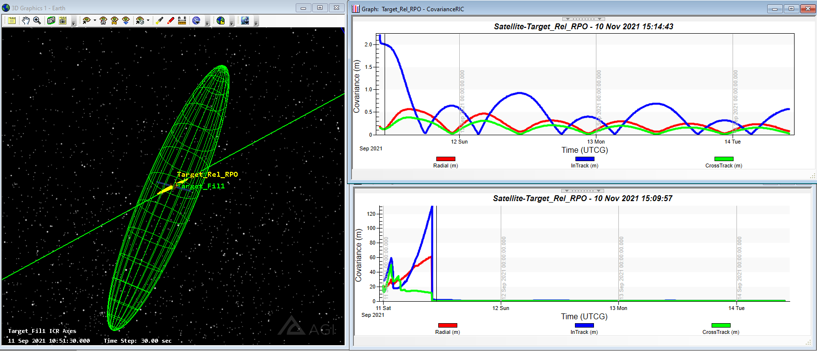 Problem statement
:
Rendezvous and Proximity Operations (RPO) missions often involve two or more valuable satellites coming into close proximity with one another. As a result, there should always be stringent requirements on the absolute and relative orbit determination quality between the two satellites. Without absolute confidence that there will not be a conjunction, the mission should not be executed. In this example, you will simulate the design process for a proximity operation in the GEO belt. The chase vehicle will approach from a drifting orbit, hop along the VBar, circumnavigate the target satellite while imaging, and then drift away. You will use the OD Simulator from Operator's Toolbox during the circumnavigation to simulate the quality of relative orbit determination achievable based on the imaging conditions between the chase and target satellites.
OT tools in Lesson 5: Smart View, Orbit Determination Simulator
Lesson 6: Modeling the Iridium-Cosmos2251 Collision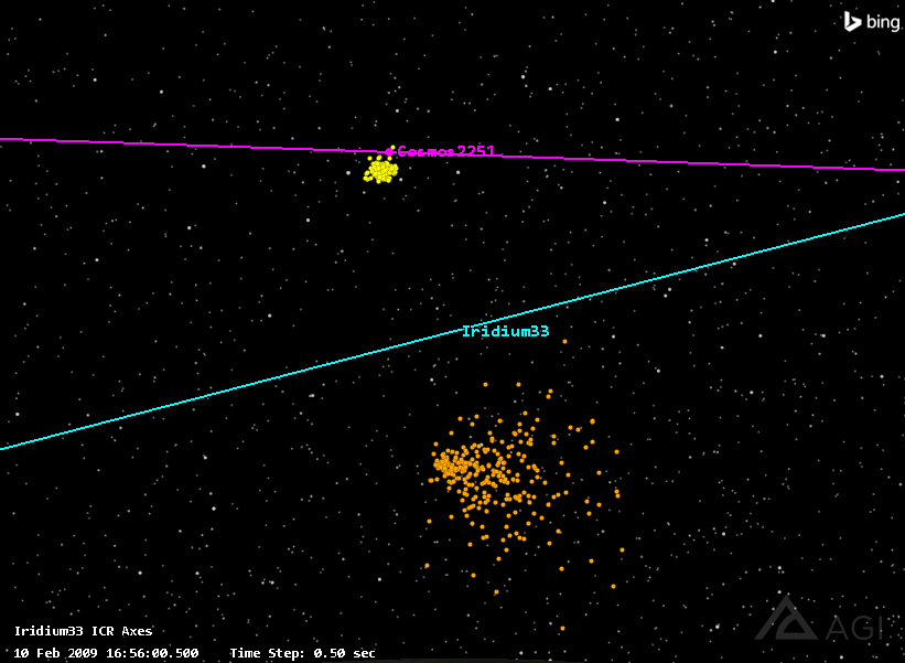 Problem statement
:
The accidental collision of Iridium33 and Cosmos2251 happened on February 10, 2009, at approximately 16:56 UTCG. This tutorial walks through evaluating the collision and the potential effects of debris. You will create the debris field using a Gaussian statistical model from the Debris Generator inside Operator’s Toolbox. See the
AGI white paper, generated by AGI, that details a post-event analysis of the breakup. This paper, along with others, were used to help validate the model used.
OT tools in Lesson 6: Debris Generator
