Operator’s Toolbox (OT) is a UI plugin for the Ansys Systems Tool Kit® (STK®) application that is designed specifically to improve the efficiency of common operational tasks. The tools made available in this plugin are mainly based on customer requests to automate certain processes within the STK application in an effort to reduce analysis time for real-world scenarios. Operator’s Toolbox contains a total of 16 tools to automate various processes, including but not limited to: predictive orbit determination, TLE import and update functionality, improved stored views functionality, automated chain/tracking interval creation, and new custom ground classification types. This article contains detailed descriptions of each tool. You can read the full overview of the toolbox in the attached documentation.
For STK application version 12.5 and later, Operator's Toolbox is included in the STK Pro install media in the following file path: C:\ProgramData\AGI\STK 12\Plugins\OperatorsToolbox. Run the setup.exe inside to install it. To obtain older versions of OT, including versions compatible with STK application version 11, please contact support@agi.com. Ansys Orbit Determination Tool Kit (ODTK®) application version 7.2 or higher is required for use of OD Simulator in the toolbox.
See Operator's Toolbox Training or tutorials using some of the tools in typical use cases.
Here are the tool descriptions.
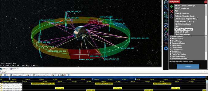
Templates
Templates is one of the most powerful tools available in Operator’s Toolbox because of its ability to quickly recreate entire object configurations of any type. The tool's purpose is to enable you to save any number of objects, with their associated properties and object dependencies, as a “template” such that you can import it into any new scenario. While there already are tools to do this on a single object basis, like the Standard Object Database, Templates allows any number of objects to be imported at once, and it is far faster than any other method currently available.
Satellite Creator
Satellite Creator is meant to be a one-stop shop for satellite creation and updates. The tool includes import options for TLE/TCE, ephemeris, orbital elements, and a custom satellite database. The custom satellite database enables you to define custom metadata for a user-specific TLE database and then import satellites based on that metadata. This tool will also update satellites to the most recent TLE data when the source is updated.
Unified Data Library TLE Import
The Unified Data Library (UDL) is an online data library that contains data that you can use inside the STK application. This tool is specifically designed to download TLE files from the UDL database. You will need to request a UDL account before you can use this tool. Additionally, you can use this tool in both unclassified and classified environments. By default, the tool is configured for unclassified use, but you can change this by modifying the UDL URL shown on the settings page. If you are working in a classified environment and need the high-side address, please reach out to AGI support to obtain this address.
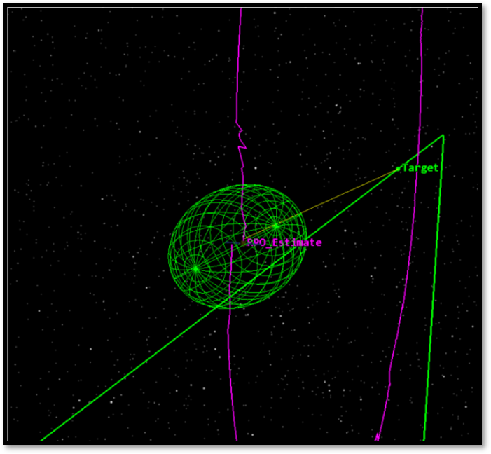
Orbit Determination (OD) Simulator
OD Simulator enables you to simulate and process satellite tracking data from any custom network of optical, radar, GPS, or space-based optical sites. OD Simulator creates a closed-loop solution using the Orbit Determination Tool Kit (ODTK) application, saving hours of time in typical analysis. The tool not only simulates tracking data for any Earth-centric satellite, but it also processes that data through an extended Kalman filter to produce a covariance estimate for the satellite. There are built-in options to scale the system error and test for anomalous situations. You can also view data metrics and covariance estimations for quick analysis.
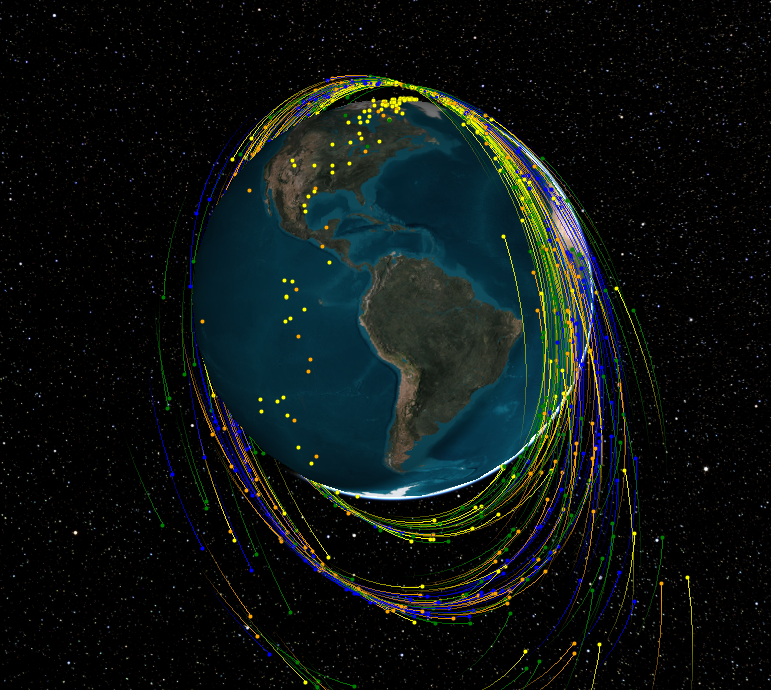
Debris Generator
The Debris Generator enables you to produce quick "What-if" analysis cases for conjunctions, intercepts, and catastrophic failures. The tool can produce debris field estimations using either a gaussian or uniform statistical model. The tool uses the STK/Astrogator® capability to create and propagate the breakup, using a high-fidelity force model for the propagation. There are built-in options for conjunction assessment and data export to make analysis even easier.
Satellite Epoch Updater
There are many instances when the scenario analysis interval changes, but the object availability interval does not change with it. The Epoch Updater is a simple tool that enables you to quickly update the availability times for any satellite in the scenario, including Astrogator satellites.
Facility Creator
Facility Creator enables you to save and modify sensor cadences. Sensor cadences, in this sense, are defined as a set of radar or optical trackers that make up a whole tracking network. This tool not only creates the site locations but also creates the attached sensor objects with all the required constraints. With this tool you can also save the cadences to a database so you can use them in any scenario once they are created.
Ground Events
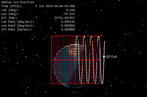
The Ground Events tool serves two major purposes. Mainly, it enables you to classify stationary ground objects into any number of user-defined types beyond the three basic types given in the STK application (place, facility, and target). It also enables you to select specific images to be associated with all ground object types when they are created. You can set these types and images on the Settings page of the main Operator’s Toolbox GUI. The second purpose of the tool is to associate a time interval and metadata with a stationary ground object. This helps define a schedule of when events are happening around the globe, and it provides an easy interface to see important information.
Smart View
Smart View is meant to boost the capabilities already found in the default stored views. A default stored view enables you to save a camera position, time, and timestep. A smart view enables you to not only include those features but also data displays, universal lead/trail settings for moving vehicles, and options to hide or show groups of objects with each view. There are also built-in view types for the 2D Graphics window.
Station Access Utility
The Station Access tool serves to expedite the process of creating large-scale access computations that involve constellations and single-link chains. The tool will not only create the chain and constellations, if required, but also add any time components to the time view, export data, and create-access reports if required.
Coverage Utility
Coverage Utility serves to expedite the process of creating coverage definitions and figures of merit. It will create the coverage definition and figure of merit (FOM) along with setting common user settings and configuring the FOM graphics based on the FOM type. There are built-in options for global coverage, Country/Region (with custom user area targets as input options), and Object Area of Interest (AOI) coverage. Object AOI coverage enables you to specify any number of ground objects as centers for coverage areas, along with their defining area around the centers.
Passive Safety Checker
Passive Safety Checker is meant for use in proximity operations or close-approach trajectories. The main goal of the tool is to verify that the acting satellite will not move to within a minimum distance from the target if something goes wrong. Passive Safety guarantees that if something goes wrong with one of the maneuvers, then the naturally generated trajectory, without any additional maneuvers, does not come within a user-specified volume around the target. You can define the volume around the satellite as a sphere or a box surrounding the target, with dimensions in the RIC frame. For STK application versions 12.7 and later, this tool is also part of the Astrogator software, which you can read about in the RPO Passive Safety Tool help.
Volume Creator
Volume Creator enables you to create analytical volumes in space based on ground range, altitude, and elevation constraints. The tool will create the volume at a specified ground location. You can use this for situational awareness, threat assessments, or any other use case involving a 3D keep-out zone or area of regard. The tool saves the volumes and locations in a database so you can use them in any scenario after they are created.
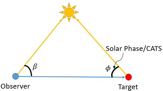
Solar Angle Utility
This tool is designed to calculate the beta angle or Solar Phase/CATS angle between any number of observers and targets. The beta angle is defined by the image below. This tool will create all of the Analysis Workbench components required to report the angle values.
Plane Crossing Utility
This tool is designed to calculate the times when a satellite or stationary ground object crosses the orbital plane of a satellite of interest. The tool will create all required Analysis Workbench components for the calculation. The tool has the option to constrain the times to specific angle bounds, enabling you to report on crossing times in and out of a region relative to an orbital plane. The tool can export the data as a report (a text file) and provides an interface to see the results internally.
Sensor Boresight View plugin
This tool will create a new 3D Graphics window that mimics what a selected sensor would see. This will size the new window and change the camera's field of view based on the sensor's settings. This works with simple conic, rectangular, and EOIR sensors. You can add several overlays to the new sensor view, including crosshairs, rulers, and an LLA data display. You can also tie the sensor view back to an existing Smart View.
