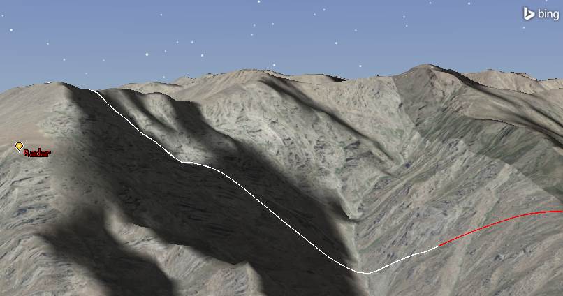
Route Vulnerability using Coverage

« Go Back

Information

 
QuestionHow do visualize locations along the route that a vehicle could be detected?
Answer
Background: As friendly vehicles traverse a route, an enemy helicopter is a looming threat. Due to the terrain, the helicopter might have access to the vehicles, but it also likely has access to a section of the route the vehicles will take. We wish to visualize the section(s) of the route to communicate the elevated level of risk.

Go to the Ground Vehicle properties, 2D Graphics Attributes: Select the Access Intervals Options available here. This option can be used to show Red when the ground vehicle is seen ('access') by the Helicopter.  If the vehicle is never seen by the object/location/vehicle/satellite when the vehicle is at that point, then the line will not go Red.  This does not take into account if the helicopter sees part of the track when the Ground Vehicle was NOT located on that same part of the track. 
Red shows vulnerability to Radar Obect

To visualize the entire route of the vehicle for the duration of the helicopter's flight, you need to use Coverage. In other words, to determine which part of the Ground Vehicle is seen by the Helicopter, Coverage should be used. Coverage allows you to overlay points along the line and then compute access for the entire duration for these points.  In the Coverage Object, there is an option for Custom Boundary where a Line Target can be selected. Coverage visualizes the route with individual boxes at given distance intervals. In the picture below you can see the boxes along the pathway. If the boxes are smaller  it looks smoother (Smaller Distance between points = Finer resolution)
 
Shows Coverage on Boundary and on Area

If you use Coverage for an Area Target defined around the Ground Vehicle's route, you get a very nice image of the region.  Coverage can then be smoothed to determine locations along the route that are protected (green) and are vulnerable (red). To do this, you need to create an Area Target and then a Coverage Definition at X km above the terrain, with Terrain Mask Constraint only on the Aircraft Object.  Use N Asset Coverage with Maximum. For the contours, have the FOM start at 0 and go to 1 and color them appropriately.  This Coverage Definition shows a good representation of the vulnerability of the Ground Vehicle along the route.
 
Shows Route Vulnerability with Coverage
TitleRoute Vulnerability using Coverage
URL NameRoute-Vulnerability-using-Coverage677634

Related Files

RouteVulnerabilityUsingCoverage.vdf