Create a texture map
You can use any texture map if you know the corner points and parameter value(s). For this article example, you will create a texture map.
- Take a screenshot of an area of interest; STK and Google Earth are good options.
- Make note of the latitude and longitude of the images corner points.
- Convert your image file into a CSV file. To do this, you can copy and modify the following MATLAB code:
a=imread('C:\FilePath\test.jpg');
b=mean(a,3);
imagesc(b)
b=b/max(b(:));
csvwrite('C:\FilePath\TextureFile.csv',b);
Set the environment variables
- Click the Windows icon and search for "Edit environment variables for your account."
- When you see the full control panel label, click it. Verify that it is the control panel for your account, not for system variables.

- Create a user variable for the CSV files location.
- Click New... to add environment variables for your account.
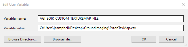
- Enter “AGI_EOIR_CUSTOM_TEXTUREMAP_FILE” into the Variable name field.
- Insert the file pathway into the Variable value field.
Ex: C:\FilePath\TextureFile.csv
- Click OK after the variable is set up to add user variable.
- Create a new variable to store the coordinates of the image in latitude and longitude.
- Click New....
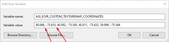
- In the Variable name field, put “AGI_EOIR_CUSTOM_TEXTUREMAP_COORDINATES”.
- In the Variable value field, insert your coordinates in the following format:
north-bound, south-bound, west-bound, east-bound
Or
top-left lat, top-left lon, top-right lat, top-right lon, bottom-left lat, bottom-left lon, bottom-right lat, bottom-right lon
*THE FORMAT OF THE COORDINATES REQUIRES COMMAS FOLLOWED BY A SPACE BETWEEN EACH POINT*
The latitude range is -90deg to 90deg; the longitude range is -180deg to 180deg.
- Click OK.
- Now set the reflectance, emissivity, and temperature coordinates of the image. Create a new environment variable with the name: AGI_EOIR_CUSTOM_REFLECTANCE_TEXTURE_FILE
- Next, click the ellipsis and go to the file location of the CSV.
- Create variables with the following names and enter the variable values of the coordinates in the same style as for latitude and longitude:
AGI_EOIR_CUSTOM_REFLECTANCE_TEXTURE_COORDINATES
AGI_EOIR_CUSTOM_EMISSIVITY_TEXTURE_COORDINATES
AGI_EOIR_CUSTOM_TEMPERATURE_TEXTURE_COORDINATES
- Lastly, create two variables with the following names; for the variable values, click the ellipsis and go to the location of the CSV.
AGI_EOIR_CUSTOM_EMISSIVITY_TEXTURE_FILE
AGI_EOIR_CUSTOM_TEMPERATURE_TEXTURE_FILE
Open STK and set up your EOIR sensor (close and reopen STK if it was already running)
This assumes an EOIR sensor is already in place.
- Make sure the plugin is marked as active by going to Edit > Preferences > UI Plugins and verifying that the Active check box is selected for EOIR Sensor Plugin.
- Then right-click the toolbar and choose to add the EOIR Sensor Plugin.
- Click your sensor with EOIR enabled.

- Open the synthetic scene.
- Right-click the synthetic scene and open the details panel.
- Change the Scene Details to Fine.
- In your image you will see a texture overlay of your custom map.
Note: Sample file is attached to this article.
